Cyclopedia – Satellite navigation for bikers!
 Anjou Tourism in the Western Loire is delighted to announce Cyclopedia - the first innovative, multi-media GPS handheld guide for cyclists and a perfect way to explore the gentle slopes of the Loire area, châteaux trails, abbeys and small towns. The system received an outstandingly positive response when it was trailed in 2007.
 It is simple to use and free – only a deposit of Euro 250 is required. Cycling groups can easily reserve Cyclopedia from one of seven local tourist offices on the “La Loire à Vélo” route in Anjou and cycle off – it is in English and an extra battery is even provided.
“La Loire à Vélo” is part of the astonishing European Rivers Cycle Route scheme, conceived in 2005, which is to link Nantes by the Atlantic Ocean to Budapest and later on to the Black Sea, a 2,400 km long journey. Brilliantly a series of hotels “Accueil Vélo” are signed up and linked to the scheme, offering comfortable beds, high-energy breakfasts, secure bicycle parks and breakdown assistance.
In the Western Loire there is currently 120 km of marked bike route from Saumur to Angers and beyond and a further 40 km around Nantes. Ultimately the Loire à Vélo trails will comprise almost 800 km linking Cuffy near Sancerre to St-Brévin-les-Pins on the Atlantic Ocean.
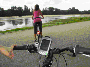
The Anjou Cyclopedia GPS system currently applies to the 65 km trail from Gennes to Montjean sur Loire. It has been meticulously thought through; not only does it allow cyclists to pinpoint their exact location but carries an extensive database of local highlights with architectural, historical, sociological and the natural surroundings detailed. The 33 stops chosen have over sixty points of interest highlighted in each section making it an unparallel and reverting tool.
Further information in English visit Angjou-tourisme.com and Loire-a-velo.fr.